Jan Jansson, also known as Johannes Janssonius, was born in Arnhem in the eastern Netherlands. After marrying the daughter of the publisher Joducus Hondius in 1612, he established a publishing business in Amsterdam. Prior to 1606, Jodocus Hondius had gained possession of the copper plates of the popular Mercator Atlas, and he continued publishing editions with the addition of newly created maps. From approximately 1630 to 1638, Jansson worked in partnership with his brother-in-law, Henricus Hondius, to issue further editions of the Mercator/Hondius atlases, to which Jansson’s name was eventually added. Polus Antarcticus is a revised version of a 1637 map first issued by Henricus Hondius in one such edition.
During the sixteenth and seventeenth centuries, the expansion of Dutch trade and widespread European interest in the New World saw a growing demand for maps to visualise these newly found lands. Amsterdam became the centre of the map trade, and cartographers and publishers gained their knowledge from the results of both Dutch and foreign voyages of discovery.
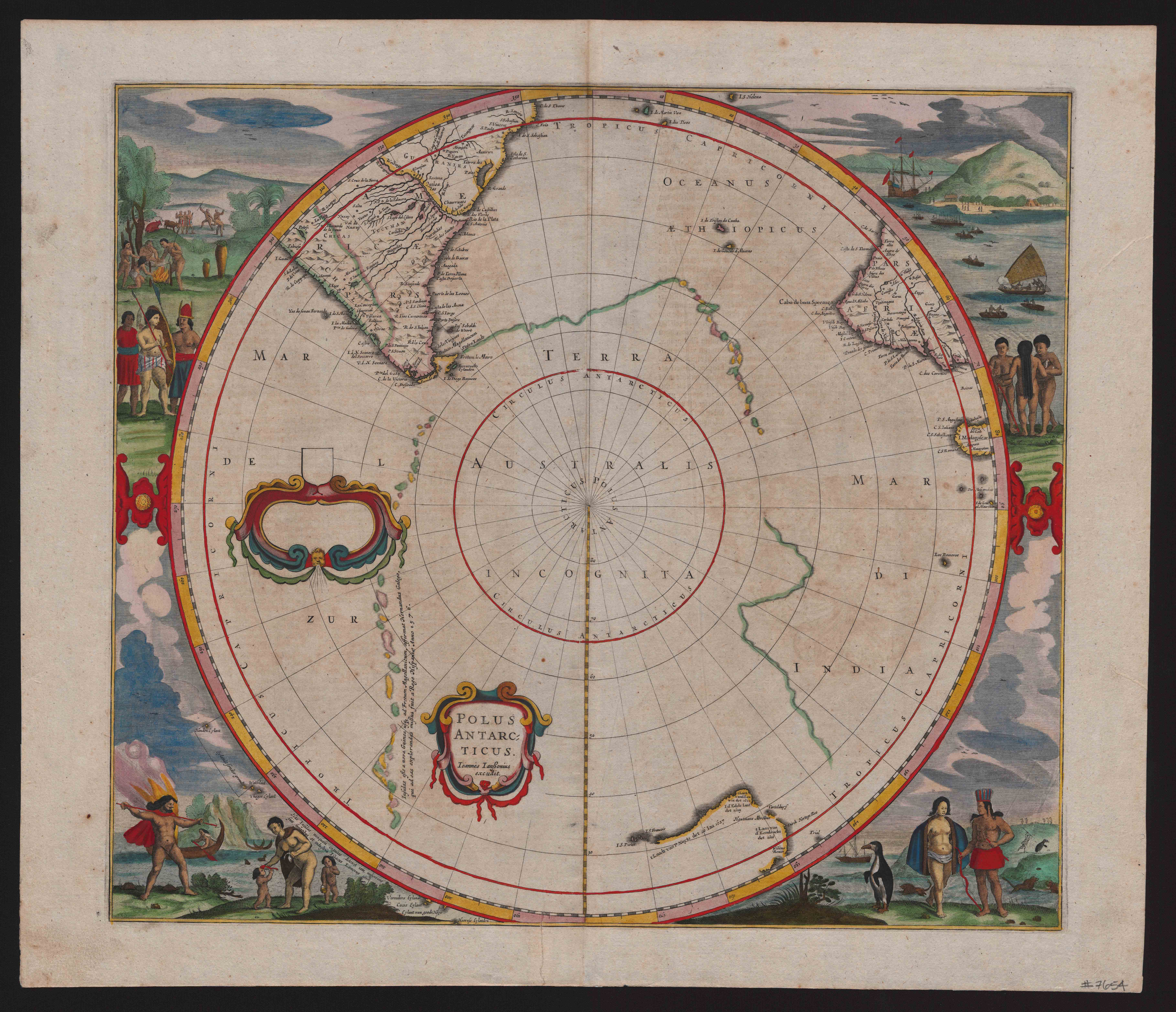
The Portuguese explorer Ferdinand Magellan, whose 1519 voyage traced the southern point of South America, had fuelled a belief in the presence of a mysterious southern land known as Terra Australis Incognita or the ‘false Continent’. The notion of an Antarctic continent – the Antipodes – had existed since the time of the Pythagoreans, who advanced the theory of a spherical earth whose equilibrium must rely on the counterweight provided by as-yet unknown southern and western landmasses. Since Antiquity, controversy had surrounded these Antipodean lands, and the desire to discover them became a compelling motive for maritime exploration. Polus Antarcticus illustrates the way in which cartographical documentation of the southern hemisphere was pieced together in stages. In 1616, the Dutch ship Eendracht explored the west coast of Australia, followed by the Leeuwin’s 1622 rounding of the continent’s south-western corner. The Dutch explorer Abel Tasman joined these isolated mapped coastlines in two voyages between 1642 and 1644. Polus Antarcticus shows these south-western Australian coastlines, and the southern regions of South America and South Africa. The map’s border depicts a range of tribal groups and their various forms of hunting, cooking, sailing and family life. Influenced by sixteenth-century ethnographical costume books, illustrated maps such as Polus Antarcticus reflect a contemporary interest in the correlation between geography, climate, and human variation.
Catherine Mahoney, University of Melbourne